A Desert Adventure
- Chris Cotton
- Aug 20, 2023
- 10 min read
Updated: Jun 16, 2025
Welcome to the first installment of my Photo Adventure Series! I'll be taking you day-by-day through some of my favorite trips and detailing my favorite hikes, places to snap a picture, and other interesting facts and stories along the way. This first piece covers one of my favorite journeys through the Desert Southwest as my Mom and I looped through portions of Nevada, Arizona, and Utah.
The Road Map
You can follow along my adventure with the map below to see some of the highlights and interesting places we visited on the trip. Be sure to click the links if you're interested in checking out any of the trails I have listed or want to learn more about the places we visited.
Day 1 - Into the Desert
The action started once we touched down in Las Vegas. After picking up a much awaited In-n-Out burger and dealing with the always difficult rental car agencies, we made our way into the desert towards Sedona. Much can be said about the striking landscape we experienced on our 4.5 hour drive, like wide open spaces and the occasional tumbleweed, but we'll focus on the highlights as we made our way into the land of the red rocks.
Views from our first hike to Cathedral Rock in Sedona, AZ
Rolling into Sedona late in the afternoon, we had just enough time to fit in a sunset hike before settling into our first hotel of the trip. Cathedral Rock sits towards the center of the valley, making it perfect to soak in views in all directions of the red rock formations and canyon walls, so it was our top pick to view the sunset. The hike itself is a healthy challenge, about 1.2 miles out and back, with 750 ft of elevation gain (straight up then straight back down). The views on the hike up and at the top are spectacular. Look to the Southeast, and you can see Courthouse Butte; look to the East and you see the Chapel of the Holy Cross.
Day 2 - The Grand Canyon
Starting early thanks to our east coast sleep schedule, we made our way out to the Devil's Bridge trail. The trail is about 4 miles long, with the majority of the trail along a winding sandy road before going up in elevation to the bridge itself. If you have a 4x4 vehicle, you can just skip the sandy road section, but alas we did not, so we trod along the full length of the trail in the AZ heat. The bridge itself is an incredible geological formation that you can actually walk across (you just have to wait your turn in the line of tourists snapping photos).
Devil's Bridge and the surrounding area in Sedona
From here we needed to trek north to our next destination, the Grand Canyon (Side note: make sure to stop at the world's only blue McDonalds on your way out of Sedona). We quickly stopped to check in at our sleeping accommodations located in Tusuyan, AZ, only 15 mins from the south rim, and set out to the park for sunset. You'll notice a trend in our schedule each day as the trip went on: wake up early for a sunrise hike, travel during the heat of the day (especially helpful when traveling during the summer), arrive at our next location in the late afternoon and then set out on a sunset hike. Not only does it keep you out of the heat but you're always going to find nice lighting if you stick to morning and evening.
Sunset views in the Grand Canyon
Everyone makes a big deal out of seeing the Grand Canyon for the first time, and I can confirm, it's quite the sight. Nothing else in the US, in my opinion, can make you feel as small as the Grand Canyon does. We made our way out to the south rim of the canyon and walked along the Rim Trail. The paved trail winds its way along the south rim for 12 miles, but we only walked a short portion of it, taking in the views at the many overlooks along the way like Mather Point and Yavapai Point. There really isn't a bad overlook on the rim trail, so you're sure to get amazing views (and photos) wherever you decide to take in the sunset.
Day 3 - Horseshoe Bend

Once again, we woke up early to catch the sun rising, this time over the Grand Canyon. The sun rays glowing over each ridge of the canyon was an incredible sight to see in person, and there were many others who woke up early to take in the scenery. If you're someone who doesn't want to deal with the crowds of a national park, especially a popular park like the Grand Canyon, getting up earlier is one of the best ways to do it. Alternatively, going to a park outside of the peak season is another great way to get parks all to yourself!
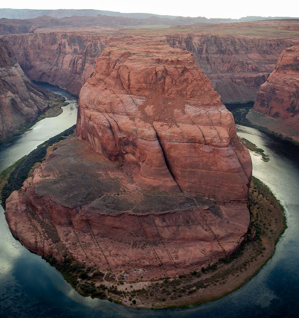
Our next destination was Page, AZ and for those who don't know where that is or what's in Page, you may be more familiar with some of the famous geological formations and parks in the area - just to name a few: Glen Canyon NRA, Horseshoe Bend (Left), Antelope Canyon, Vermillion Cliffs NM, and so many more. We made a stop at Horse Shoe Bend with it's newly renovated trail, only 1.5 miles and a must stop for anyone driving through the area. Sadly, our tour of Antelope Canyon (another must see) was canceled due to Covid. Note that tours of Antelope Canyon require a reservation because it's located on Navajo land, so plan ahead!
Day 4 - Driving Down a Dirt Road
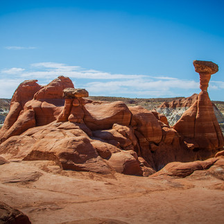
Leaving the Grand Canyon State behind, we finally entered Utah. Our destination was Bryce Canyon, but we had plenty of side quests lined up on our way there, the first of which was the Toadstool Hoodoos. This short trail, directly off of US-89, is easy to blow right by. But it's a great treat for those who decide to make the stop, getting to witness numerous hoodoos in the stark desert. From this point, we deviated from the typical route to Bryce Canyon (US-89), and opted to take the more scenic and rugged 60 mile dirt road that is Cottonwood Canyon Road. Along this road we were able to experience the desert in much more intimate way. The washboarding along the dirt road, whether we liked it or not, required us to slow down and take in the views. On the dirt road we made stops at Cottonwood Narrows and Grosvenor Arch.
Toadstool Hoodoos, Cottonwood Canyon, and Grosvenor Arch.

Finally we made our way into Bryce Canyon for the afternoon, and just like before, we dropped off our things and headed out for a sunset hike! We were joined by my good friend Donovan (!!) and proceeded to hike my favorite trail of the entire trip! The Wall Street and Queens Garden Loop trail will make you feel like you just stepped into the Star Wars universe. Golden orange hoodoos tower over you around every corner and you almost expect to be greeted by some crazy alien creatures as you walk along the trail. The trail is 3 miles, but luckily in the afternoon, it's mostly shaded thanks to the hoodoos towering over the trail. Once we wrapped up the hiking, we made our way to Bryce Point to catch the last glows of sunlight before calling it a day.
Day 5 - Difficulty in the Desert
Starting with another sunrise, we made our way to the aptly named Sunrise Point in Bryce Canyon. The sun lit up the orange spires that fill the Bryce Canyon Amphitheater. At no other sunrise have I found myself trying to rifle off as many photos as I could. Each and every angle of the canyon was beautiful in the morning light. To this day, it is one of my most memorable sunrises.
An incredible sunrise at Bryce Canyon National Park
As with any trip, the good times can last forever. Our luck was running high with all the amazing sunrises and sunsets, that it almost seemed like it wouldn't ever stop. Well, shortly after our sunrise in Bryce Canyon, we made our way to Grand Staircase - Escalante National Monument for another hike. As we drove down another washboard dirt road, we heard a pop and warning lights started flashing. We had a flat tire... in the middle of the desert. As the sun beat down, we changed the flat with a small spare tire and headed back to the nearest town of Escalante, UT to get the tire patched up. We took a few hours to explore the town on foot and grab some food from a local grocery store. Once the car was fixed up, we got back on the road with our maps set for Capitol Reef National Park. Along the way we made stops at the Upper Calf Creek Falls trail and took in sweeping views at almost 10,000' of elevation passing over Boulder Mountain.

Changing a flat in the desert
Day 6 - Oases in the Desert
No visit to Capitol Reef is complete without a visit to the Gifford Homestead in Fruita, UT. This homestead still operates today where it has been fashioned into a country store, selling items like jam, local craft items, and, the crowd favorite, freshly baked pies. After we fueled up with some sweet carbs, we traveled down to the Capitol Gorge trail. This trail not only features beautiful desert scenery, but it also has some 150+ year old history. Early Mormon settlers carved their names into the walls of the gorge as they traveled west, and many of the names and dates of passage are still there today!
Exploring Capitol Reef National Park
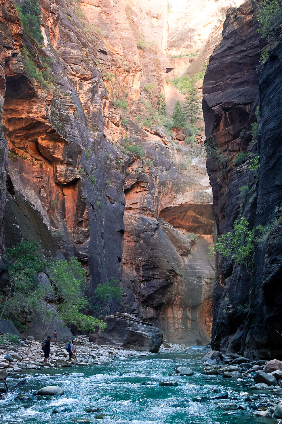
After we finished our hike , we left the Reef and headed Southwest towards Zion National Park, our fourth and final National Park of the trip. Arriving in the early afternoon, we grabbed the first available shuttle (the only way to drive up through the canyon) and made a beeline to the trailhead for the Narrows (Left). If you plan on heading to the narrows, make sure you bring your water shoes. The trail navigates the Virgin River through tight canyon walls and occasionally requires walking chest high through the water. We made it about a mile upstream before turning around (the full trail is 9 miles out and back) to ensure that we could make it back before the final shuttle left the station. To cap off a busy day, we got in our car and drove through the Zion Mount Carmel Tunnel to the Zion Canyon Overlook. The overlook provides a view of the Temples and Towers of the Virgin, a famous set of Navajo sandstone peaks in the park.
Day 7 - Taking a (Cedar) Break(s)
For the first time during our trip, we were going to be sleeping in the same place we woke up, so we were able to have a restful morning in Springdale, UT. When we finally got going, we drove through East Zion and made our way north to Cedar Breaks National Monument. This lesser known and extremely underrated park features many of the same geological formations as Bryce Canyon as well as some of the highest elevations in Southwestern Utah (Up to 11,315' of elevation!). From certain overlooks you can look south and see the beginning of Zion Canyon and many of the mountain peaks within the park.
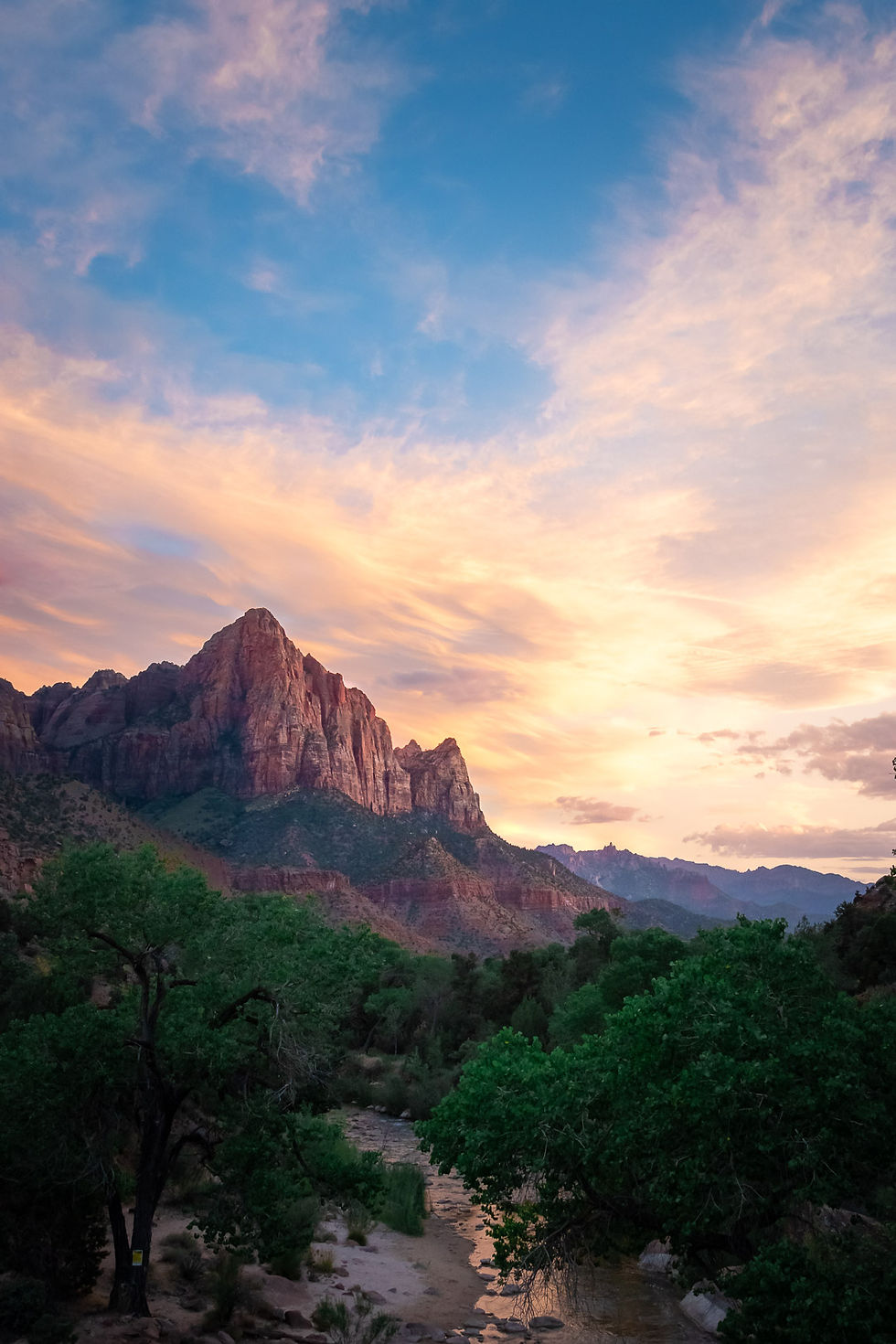
Keeping with the slow pace of our rest day, we drove back into Springdale, at the entrance of Zion, and decided to just be tourists for the afternoon. Springdale offers many amenities that you wouldn't normally find just steps away from a National Park. The food will make you feel like you're back in a big city while you gaze out on the sharp rock spires of Zion. We then took some short trails as the sun was setting and caught the last bits of sunlight hitting The Watchman (Right) before heading back to our hotel. With our day seemingly over, we were ready to pack it up and hit the hay one last time in the wilderness. But before we could, on our way home from the park we caught a glimpse of a long and bright trail across the night sky. It was none other than the NEOWISE Comet! We pulled off onto a dark road to try and get a better look and were able to see it with the naked eye. What an awesome surprise!

Comet NEOWISE in the night sky over Utah
Day 8 - The Home Stretch
With a week of travel under our belts, we were ready to make the final leg of our adventure. We re-entered Nevada and drove south towards Vegas, with two more stops left on our itinerary. The first was the Valley of Fire State Park. Located only 45 mins away from Las Vegas, it's an easy day trip if you're spending time in the Sin City and need to take a break from all the lights and action. We took a drive down the picturesque Mouse Tank Road and scrambled across red rocks to our heart's content. Our second and final stop was much closer to Vegas and arguably just as spectacular at the Red Rock Canyon National Conservation Area. If you're tired after a long trip like we were, you'll love to just go for a ride around the Scenic Loop Drive. This 15 mile loop lets you take in all of the scenery from the comfort of your car, but there are some great pull offs and overlooks to stretch your legs and take a hike if you're up for it (check out the Calico Tanks Trail or the Petroglyph Wall Trail).
Our last stops of the trip: Valley of Fire SP and Red Rock Canyon NRA
That about wraps it up for the first iteration of the Photo Adventure Series. I hope you enjoyed it and hope that any of the information you took in can help inspire some trips in the future! Let me know what you thought, and leave a comment below! If you want to check out more images like this, check out my Desert Southwest Gallery. And if you want to bring part of the desert home with you, consider checking out some of my featured prints from the Desert Southwest here! Thanks for stopping by, and stayed tuned for more Photo Adventure content soon!






Comments